
This page is no longer maintained: please proceed to: agci.org/iron
About the Roaring Fork Observation Network Stations

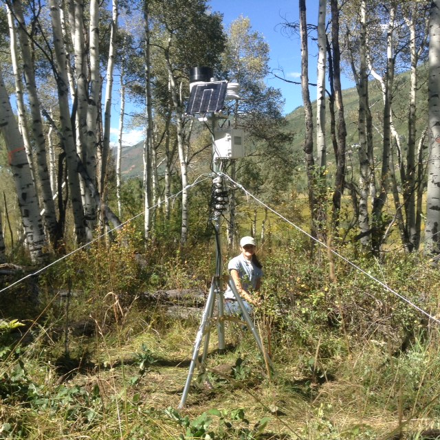
The Sky Mountain Station was installed and began collecting data in the summer of 2012. Located at an elevation of around 8,380 feet, the station is located in a stand of aspens. This particular stand is of interest because it occurs on a north-facing slope that is primarily covered with woody shrubs such as sage, scrub-oak, and service berries. This stand of aspens may be a stand in transition. This station is powered by solar panel and measures air temperature, relative humidity, soil moisture at 2, 8, and 20 inch depths. In summer of 2015, soil temperature at 8 inches was added as well.
Soil at a glance:
Loam | 10.6% organic matter | 60.5ppm NO3 | 14ppm P | pH 5.
Data
Live data are collected every 20 minutes and transmitted every hour. These data have not been checked for anomalies or potential false readings. Rain readings should not be considered accurate when temperatures are below freezing. Archived data are available on the Data Page.
The Sky Mountain station is monitored by AGCI with support from ACES, Pitkin County Open Space and Trails, and City of Aspen.
Smuggler Mountain
 The Smuggler Mountain Station was installed in 2012 and began collecting data in the summer of 2013. Located at an elevation of around 8,970 feet, the station is located in a mixed conifer forest that includes spruce, pine, fir, and some aspen. This station is powered by solar panel and measures air temperature, relative humidity, soil moisture at 2, 8, and 20 inch depths. In the fall of 2014, soil temperature at 8 inches was added as well.
Soil at a glance:
Loam | 0.9% organic matter | 0.5 ppm NO3 | 30 ppm P | pH 4.7
Data
Live data are collected every 20 minutes and transmitted every hour. These data have not been checked for anomalies or potential false readings. Rain readings should not be considered accurate when temperatures are below freezing. Archived data are available on the Data Page.
The Smuggler Mountain Station is monitored by AGCI with support from ACES, Pitkin County Open Space and Trails, and City of Aspen.
 Glassier Ranch
The Glassier Ranch Station was installed and began collecting data in the summer of 2014. Located at an elevation of around 6,460 feet, the station is in a riparian zone near the Roaring Fork River and is surrounded by tall grasses. This area was heavily impacted by ranching and agriculture previous to its current ownership by Pitkin County Open Space and Trails, and its soil moisture content may still be influenced by nearby irrigation. This station is powered by a solar panel and measures air temperature, relative humidity, soil temperature at 8 inches, and soil moisture at 2, 8, 20, and 40 inch depths.
Soil at a Glance:
Sandy Loam | 33.6% organic matter | 9 ppm NO3 | 100 ppm P | pH 6.3
Data:
Live data are collected every 20 minutes and transmitted every hour. These data have not been checked for anomalies or potential false readings. Rain readings should not be considered accurate when temperatures are below freezing. Archived data are available on the Data Page.
The Glassier Mountain Station is monitored by AGCI with support from Pitkin County Open Space and Trails.
 Brush Creek
The Brush Creek Station was installed and began collecting data in the summer of 2014. Located at an elevation of around 7,780 feet, the station is in a high altitude meadow near Brush Creek and is surrounded primarily by smooth brome. This area was previously heavily impacted by ranching and is designated for future restoration by Pitkin County Open Space and Trails. This station is powered by a solar panel and measures air temperature, relative humidity, soil temperature at 8 inches, and soil moisture at 2, 8, and 20 inch depths.
Soil at a Glance:
Clay | 6.8% organic matter | 5.4 ppm NO3 | 4 ppm P | pH 6.5
Data:
Live data are collected every 20 minutes and transmitted every hour. These data have not been checked for anomalies or potential false readings. Rain readings should not be considered accurate when temperatures are below freezing. Archived data are available on the Data Page.
The Brush Creek Station is monitored by AGCI with support from Pitkin County Open Space and Trails.
 Glenwood Springs
The Glenwood Springs Station was installed and began collecting data in the summer of 2015. It is situated on City of Glenwood Springs Property. The station is at an elevation of around 6,200 feet, and is located on a slope in a small clearing amongst dense growing scrub oak in very rocky soil. This station is powered by a solar panel and measures air temperature, relative humidity, soil temperature at 8 inches, and soil moisture at 2, 8, and 20 inch depths.
Soil at a Glance:
Clay Loam | 4.8% organic matter | 3.0 ppm NO3 | 5.4 ppm P | pH 7.5
Data:
Live data are collected every 20 minutes and transmitted every hour. These data have not been checked for anomalies or potential false readings. Rain readings should not be considered accurate when temperatures are below freezing. Archived data will be available on Data Page beginning in September of 2015.
The Glenwood Springs Station is monitored by AGCI with funding from the John Denver Aspenglow Foundation and permission and citing assistance from the City of Glenwood Springs.

Northstar Preserve
Two stations were installed at Northstar in the fall of 2015. The land is managed by Pitkin County, and two companion stations are located near each other: one in a stand of aspen trees and the other in a transition zone between a fen and a meadow. The area is considered of special interest as there is curiosity as to whether the ecosystems adjacent to the nearby riparian zone may be drying out over time. The stations are at an elevation of roughly 8,050 feet. One station is located on a level area within a stand of aspens, east of the nearest slope. The second station is located in a transition zone between a fen and meadow of mixed grasses. The transition zone station had very different soil types at different depths, becoming progressively more sandy and lighter in color with an increase in depth. Both stations are powered by a solar panel and measures soil temperature at 8 inches, and soil moisture at 2, 8, and 20 inch depths. The aspen station additionally measures rain, air temperature, and relative humidity. The transition station will soon be equipped to measure snow depth.
Soil at a Glance:
Northstar Aspen Grove:
Clay Loam | 16.6% organic matter | 5.0 ppm NO3 | 20.5 ppm P | pH 6.9
Northstar Transition:
Clay Loam | 10.8% organic matter | 3.1 ppm NO3 | 11.2 ppm P | pH 7.3
Data:
Live data are collected every 20 minutes and transmitted every hour and can be found here for the aspen station and here for the transition station. These data have not been checked for anomalies or potential false readings. Rain readings should not be considered accurate when temperatures are below freezing. Archived data will be available on Data Page beginning in November of 2015.
The Northstar station is monitored by AGCI with funding from the Pitkin County Open Space and Trails.
The Smuggler Mountain Station is monitored by AGCI with support from ACES, Pitkin County Open Space and Trails, and City of Aspen.

The Glassier Ranch Station was installed and began collecting data in the summer of 2014. Located at an elevation of around 6,460 feet, the station is in a riparian zone near the Roaring Fork River and is surrounded by tall grasses. This area was heavily impacted by ranching and agriculture previous to its current ownership by Pitkin County Open Space and Trails, and its soil moisture content may still be influenced by nearby irrigation. This station is powered by a solar panel and measures air temperature, relative humidity, soil temperature at 8 inches, and soil moisture at 2, 8, 20, and 40 inch depths.
Soil at a Glance:
Sandy Loam | 33.6% organic matter | 9 ppm NO3 | 100 ppm P | pH 6.3
Data:
Live data are collected every 20 minutes and transmitted every hour. These data have not been checked for anomalies or potential false readings. Rain readings should not be considered accurate when temperatures are below freezing. Archived data are available on the Data Page.
The Glassier Mountain Station is monitored by AGCI with support from Pitkin County Open Space and Trails.

The Brush Creek Station was installed and began collecting data in the summer of 2014. Located at an elevation of around 7,780 feet, the station is in a high altitude meadow near Brush Creek and is surrounded primarily by smooth brome. This area was previously heavily impacted by ranching and is designated for future restoration by Pitkin County Open Space and Trails. This station is powered by a solar panel and measures air temperature, relative humidity, soil temperature at 8 inches, and soil moisture at 2, 8, and 20 inch depths.
Clay | 6.8% organic matter | 5.4 ppm NO3 | 4 ppm P | pH 6.5
Data:
Live data are collected every 20 minutes and transmitted every hour. These data have not been checked for anomalies or potential false readings. Rain readings should not be considered accurate when temperatures are below freezing. Archived data are available on the Data Page.
The Brush Creek Station is monitored by AGCI with support from Pitkin County Open Space and Trails.

The Glenwood Springs Station was installed and began collecting data in the summer of 2015. It is situated on City of Glenwood Springs Property. The station is at an elevation of around 6,200 feet, and is located on a slope in a small clearing amongst dense growing scrub oak in very rocky soil. This station is powered by a solar panel and measures air temperature, relative humidity, soil temperature at 8 inches, and soil moisture at 2, 8, and 20 inch depths.
Soil at a Glance:
Clay Loam | 4.8% organic matter | 3.0 ppm NO3 | 5.4 ppm P | pH 7.5
Data:
Live data are collected every 20 minutes and transmitted every hour. These data have not been checked for anomalies or potential false readings. Rain readings should not be considered accurate when temperatures are below freezing. Archived data will be available on Data Page beginning in September of 2015.
The Glenwood Springs Station is monitored by AGCI with funding from the John Denver Aspenglow Foundation and permission and citing assistance from the City of Glenwood Springs.
Northstar Preserve
Two stations were installed at Northstar in the fall of 2015. The land is managed by Pitkin County, and two companion stations are located near each other: one in a stand of aspen trees and the other in a transition zone between a fen and a meadow. The area is considered of special interest as there is curiosity as to whether the ecosystems adjacent to the nearby riparian zone may be drying out over time. The stations are at an elevation of roughly 8,050 feet. One station is located on a level area within a stand of aspens, east of the nearest slope. The second station is located in a transition zone between a fen and meadow of mixed grasses. The transition zone station had very different soil types at different depths, becoming progressively more sandy and lighter in color with an increase in depth. Both stations are powered by a solar panel and measures soil temperature at 8 inches, and soil moisture at 2, 8, and 20 inch depths. The aspen station additionally measures rain, air temperature, and relative humidity. The transition station will soon be equipped to measure snow depth.
Soil at a Glance:
Northstar Aspen Grove:
Clay Loam | 16.6% organic matter | 5.0 ppm NO3 | 20.5 ppm P | pH 6.9
Northstar Transition:
Clay Loam | 10.8% organic matter | 3.1 ppm NO3 | 11.2 ppm P | pH 7.3
Data:
Live data are collected every 20 minutes and transmitted every hour and can be found here for the aspen station and here for the transition station. These data have not been checked for anomalies or potential false readings. Rain readings should not be considered accurate when temperatures are below freezing. Archived data will be available on Data Page beginning in November of 2015.
The Northstar station is monitored by AGCI with funding from the Pitkin County Open Space and Trails.